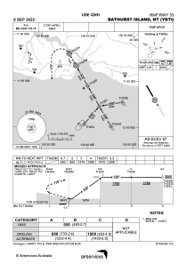
IAC chart of YBTI
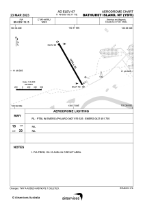
 ADC chart of YBTI
 Satellite view of YBTI
ADC chart of YBTI
Satellite view of YBTI
Sorry, we have no imagery here.
Sorry, we have no imagery here.
Sorry, we have no imagery here.
Sorry, we have no imagery here.
Sorry, we have no imagery here.
Sorry, we have no imagery here.


YBTI - Bathurst Island
Located in Bathurst Island, Australia
ICAO - YBTI, IATA - BRT
Data provided by AirmateGeneral information
Coordinates: S11°46'9" E130°37'11"
Elevation is 67 feet MSL.
View others Airports in Northern Territory
Operational data
Special qualification required
Current time UTC:
Current local time:
Weather at : YPDN - Darwin ( 77 km )
METAR: YPDN 120430Z 08010KT 9999 SCT029 SCT400 31/26 Q1008
TAF: TAF YPDN 120217Z 1203/1306 07014KT 9999 SCT030 FM120900 07007KT 9999 -RA SCT025 FM130100 09008KT 9999 -RA SCT035 INTER 1209/1306 1000 +SHRA BKN008 SCT025TCU PROB30 TEMPO 1214/1306 VRB15G25KT 0500 +TSRA BKN005 SCT025CB
Communications frequencies: [VIEW]
Runways:
| RWY identifier | QFU | Length (ft) | Width (ft) | Surface | LDA (ft) |
| 15 | 150° | 4823 | 98 | ASP | |
| 33 | 330° | 4823 | 98 | ASP |
Airport contact information
Address: Bathurst Island Australia
Satellite view of YBTI
Sorry, we have no imagery here.
Sorry, we have no imagery here.
Sorry, we have no imagery here.
Sorry, we have no imagery here.
Sorry, we have no imagery here.
Sorry, we have no imagery here.