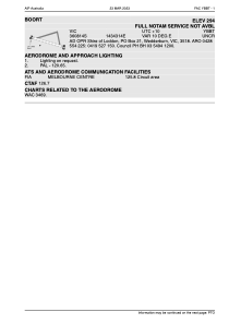
ADC chart of YBBT
 Satellite view of YBBT
Satellite view of YBBT
Sorry, we have no imagery here.
Sorry, we have no imagery here.
Sorry, we have no imagery here.
Sorry, we have no imagery here.
Sorry, we have no imagery here.


YBBT - Boort
Located in Boort, Australia
ICAO - YBBT, IATA -
Data provided by AirmateGeneral information
Coordinates: S36°8'19" E143°43'22"
Elevation is 298 feet MSL.
Magnetic variation is 10° East View others Airports in Victoria
Operational data
Special qualification required
Current time UTC:
Current local time:
Weather at : - ( 0 km )
METAR: ULOO 050825Z 04005MPS 020V080 9999 SCT026CB BKN040 06/M06 Q1007 R01/010060 NOSIG RMK QFE751
Communications frequencies: [VIEW]
Runways:
| RWY identifier | QFU | Length (ft) | Width (ft) | Surface | LDA (ft) |
| 10 | 0° | 3608 | 0 | G | |
| 28 | 0° | 3608 | 0 | G | |
| YBOOR | 0° | 0 | 0 | UNK |
Airport contact information
Address: Boort Australia
Satellite view of YBBT
Sorry, we have no imagery here.
Sorry, we have no imagery here.
Sorry, we have no imagery here.
Sorry, we have no imagery here.
Sorry, we have no imagery here.