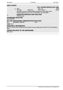
ADC chart of YALG
 Satellite view of YALG
Satellite view of YALG
Sorry, we have no imagery here.
Sorry, we have no imagery here.
Sorry, we have no imagery here.
Sorry, we have no imagery here.
Sorry, we have no imagery here.
Sorry, we have no imagery here.


YALG - Adels Grove
Located in Lawn Hill, Australia
ICAO - YALG, IATA -
Data provided by AirmateGeneral information
Coordinates: S18°41'40" E138°31'42"
Elevation is 429 feet MSL.
Magnetic variation is 5° East View others Airports in Queensland
Operational data
Special qualification required
Current time UTC:
Current local time:
Weather at : - ( 0 km )
METAR: UUOO 022258Z 36002MPS 330V040 9999 BKN011 08/06 Q1014 R30/010070 NOSIG RMK QFE747
Communications frequencies: [VIEW]
Runways:
| RWY identifier | QFU | Length (ft) | Width (ft) | Surface | LDA (ft) |
| 05 | 0° | 3707 | 0 | N | |
| 23 | 0° | 3707 | 0 | N | |
| 06 | 60° | 2129 | 116 | GRAV | |
| 24 | 240° | 2129 | 116 | GRAV |
Airport contact information
Address: Lawn Hill Australia
Satellite view of YALG
Sorry, we have no imagery here.
Sorry, we have no imagery here.
Sorry, we have no imagery here.
Sorry, we have no imagery here.
Sorry, we have no imagery here.
Sorry, we have no imagery here.