ADC chart of YAAP
 Satellite view of YAAP
Satellite view of YAAP
Sorry, we have no imagery here.
Sorry, we have no imagery here.
Sorry, we have no imagery here.
Sorry, we have no imagery here.
Sorry, we have no imagery here.
Sorry, we have no imagery here.


YAAP - Pinkenba
Located in Pinkenba, Australia
ICAO - , IATA -
Data provided by AirmateGeneral information
Coordinates: S27°26'8" E153°6'44"
Elevation is 6 feet MSL.
View others Airports in Queensland
Operational data
Special qualification required
Current time UTC:
Current local time:
Weather at : YBBN - Brisbane ( 6 km )
METAR: YBBN 022030Z 20007KT 9999 FEW005 BKN050 BKN175 20/20 Q1008
TAF: TAF AMD YBBN 022015Z 0220/0400 21007KT 9999 -DZ FEW006 BKN016 FM030000 15007KT 9999 -SHRA SCT025 FM031200 21006KT 9999 NSW SCT015 TEMPO 0220/0300 3000 SHRA BKN005 TEMPO 0312/0323 9999 BKN007
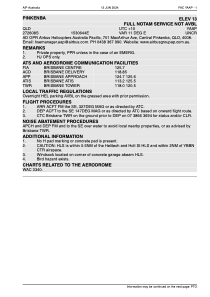
Communications frequencies: [VIEW]
Runways:
Airport contact information
Address: Pinkenba Australia
Satellite view of YAAP
Sorry, we have no imagery here.
Sorry, we have no imagery here.
Sorry, we have no imagery here.
Sorry, we have no imagery here.
Sorry, we have no imagery here.
Sorry, we have no imagery here.