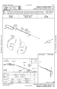
IAC chart of Y55
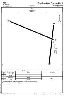
 ADC chart of Y55
 Satellite view of Y55
ADC chart of Y55
Satellite view of Y55
Sorry, we have no imagery here.
Sorry, we have no imagery here.
Sorry, we have no imagery here.
Sorry, we have no imagery here.
Sorry, we have no imagery here.
Sorry, we have no imagery here.


Y55 - Crandon/Steve Conway Muni
Located in Crandon, United States
ICAO - Y55, IATA -
Data provided by AirmateGeneral information
Coordinates: N45°31'22" W88°55'42"
Elevation is 1650 feet MSL.
Magnetic variation is -03° East View others Airports in Wisconsin
Operational data
Special qualification required
Current time UTC:
Current local time:
Weather at : KAIG - Langlade County ( 43 km )
METAR: KAIG 301555Z AUTO 30008KT 10SM SCT085 14/09 A2980 RMK AO2 T01360094
Communications frequencies: [VIEW]
Runways:
| RWY identifier | QFU | Length (ft) | Width (ft) | Surface | LDA (ft) |
| 01 | 0° | 2742 | 100 | GRASS | |
| 19 | 0° | 2742 | 100 | GRASS | |
| 12 | 0° | 3550 | 75 | ASPH | |
| 30 | 0° | 3550 | 75 | ASPH |
Airport contact information
Address: Crandon United States
Satellite view of Y55
Sorry, we have no imagery here.
Sorry, we have no imagery here.
Sorry, we have no imagery here.
Sorry, we have no imagery here.
Sorry, we have no imagery here.
Sorry, we have no imagery here.