ADC chart of XA66
 Satellite view of XA66
Satellite view of XA66
Sorry, we have no imagery here.
Sorry, we have no imagery here.
Sorry, we have no imagery here.
Sorry, we have no imagery here.
Sorry, we have no imagery here.
Sorry, we have no imagery here.


XA66 - El Jardin Ranch
Located in Encinal, United States
ICAO - XA66, IATA -
Data provided by AirmateGeneral information
Coordinates: N28°4'26" W99°17'5"
Elevation is 485 feet MSL.
Magnetic variation is 05° East View others Airports in Texas
Operational data
Special qualification required
Current time UTC:
Current local time:
Weather at : KCOT - Cotulla-La Salle County ( 43 km )
METAR: KCOT 020853Z AUTO 14005KT 8SM CLR 24/21 A2949 RMK AO2 SLP976 60000 T02440206 56009
TAF: KCOT 020520Z 0206/0306 15012G20KT P6SM BKN250 WS020/18045KT FM021200 VRB06KT P6SM FEW025 BKN250 FM030400 12012KT P6SM SKC
Communications frequencies: [VIEW]
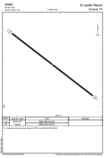
Runways:
| RWY identifier | QFU | Length (ft) | Width (ft) | Surface | LDA (ft) |
| 12 | 127° | 6302 | 80 | ASPH | |
| 30 | 307° | 6302 | 80 | ASPH |
Airport contact information
Address: Encinal United States
Satellite view of XA66
Sorry, we have no imagery here.
Sorry, we have no imagery here.
Sorry, we have no imagery here.
Sorry, we have no imagery here.
Sorry, we have no imagery here.
Sorry, we have no imagery here.