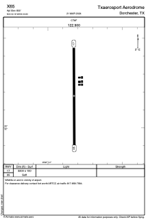
ADC chart of X65
 Satellite view of X65
Satellite view of X65
Sorry, we have no imagery here.
Sorry, we have no imagery here.
Sorry, we have no imagery here.
Sorry, we have no imagery here.
Sorry, we have no imagery here.
Sorry, we have no imagery here.


X65 - Txaerosport Aerodrome
Located in Dorchester, United States
ICAO - X65, IATA -
Data provided by AirmateGeneral information
Coordinates: N33°32'11" W96°40'50"
Elevation is 855 feet MSL.
View others Airports in Texas
Operational data
Special qualification required
Current time UTC:
Current local time:
Weather at : KGYI - North Texas Rgnl/Perrin Fld ( 20 km )
METAR: KGYI 020435Z AUTO 16025G30KT 7SM SCT020 SCT027 23/20 A2949 RMK AO1 T02330204 TSNO
Communications frequencies: [VIEW]
Runways:
| RWY identifier | QFU | Length (ft) | Width (ft) | Surface | LDA (ft) |
| 17 | 0° | 3200 | 100 | GRASS | |
| 35 | 0° | 3200 | 100 | GRASS |
Airport contact information
Address: Dorchester United States
Satellite view of X65
Sorry, we have no imagery here.
Sorry, we have no imagery here.
Sorry, we have no imagery here.
Sorry, we have no imagery here.
Sorry, we have no imagery here.
Sorry, we have no imagery here.