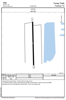
ADC chart of X09
 Satellite view of X09
Satellite view of X09
Sorry, we have no imagery here.
Sorry, we have no imagery here.
Sorry, we have no imagery here.
Sorry, we have no imagery here.
Sorry, we have no imagery here.
Sorry, we have no imagery here.


X09 - Covey Trails
Located in Fulshear, United States
ICAO - X09, IATA -
Data provided by AirmateGeneral information
Coordinates: N29°41'24" W95°50'26"
Elevation is 130 feet MSL.
Magnetic variation is 06° East View others Airports in Texas
Operational data
Special qualification required
Current time UTC:
Current local time:
Weather at : KTME - Houston Exec ( 14 km )
METAR: KTME 020035Z AUTO 18013KT 8SM CLR 25/21 A2966 RMK AO2
Communications frequencies: [VIEW]
Runways:
| RWY identifier | QFU | Length (ft) | Width (ft) | Surface | LDA (ft) |
| 17 | 178° | 3352 | 100 | GRASS | |
| 35 | 358° | 3352 | 100 | GRASS |
Airport contact information
Address: Fulshear United States
Satellite view of X09
Sorry, we have no imagery here.
Sorry, we have no imagery here.
Sorry, we have no imagery here.
Sorry, we have no imagery here.
Sorry, we have no imagery here.
Sorry, we have no imagery here.