ADC chart of WS51
 Satellite view of WS51
Satellite view of WS51
Sorry, we have no imagery here.
Sorry, we have no imagery here.
Sorry, we have no imagery here.
Sorry, we have no imagery here.
Sorry, we have no imagery here.


WS51 - Leeward Farm
Located in Soldiers Grove, United States
ICAO - WS51, IATA -
Data provided by AirmateGeneral information
Coordinates: N43°21'10" W90°40'52"
Elevation is 1068 feet MSL.
Magnetic variation is 00° East View others Airports in Wisconsin
Operational data
Special qualification required
Current time UTC:
Current local time:
Weather at : KOVS - Boscobel ( 21 km )
METAR: KOVS 210553Z AUTO VRB04KT 10SM -RA OVC012 08/07 A2974 RMK AO2 SLP075 P0001 60001 T00830072 10089 20083 401060056 55003
Communications frequencies: [VIEW]
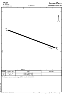
Runways:
| RWY identifier | QFU | Length (ft) | Width (ft) | Surface | LDA (ft) |
| 11 | 0° | 3791 | 100 | ASPH | |
| 29 | 0° | 3791 | 100 | ASPH |
Airport contact information
Address: Soldiers Grove United States
Satellite view of WS51
Sorry, we have no imagery here.
Sorry, we have no imagery here.
Sorry, we have no imagery here.
Sorry, we have no imagery here.
Sorry, we have no imagery here.