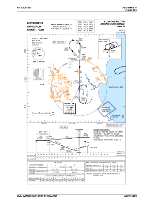
IAC chart of WMKD
 Satellite view of WMKD
Satellite view of WMKD
Sorry, we have no imagery here.
Sorry, we have no imagery here.
Sorry, we have no imagery here.
Sorry, we have no imagery here.
Sorry, we have no imagery here.
Sorry, we have no imagery here.


WMKD - Kuantan
Located in Kuantan, Malaysia
ICAO - WMKD, IATA - KUA
Data provided by AirmateGeneral information
Coordinates: N3°46'11" E103°12'34"
Elevation is 55 feet MSL.
View others Airports in Pahang
Operational data
Special qualification required
Current time UTC:
Current local time:
Weather
METAR: WMKD 111600Z VRB02KT 9999 FEW017CB 26/24 Q1010 NOSIG
Communications frequencies: [VIEW]
Runways:
| RWY identifier | QFU | Length (ft) | Width (ft) | Surface | LDA (ft) |
| 18 | 183° | 8999 | 148 | ASP | |
| 36 | 3° | 8999 | 148 | ASP |
Airport contact information
Address: Kuantan Malaysia
Satellite view of WMKD
Sorry, we have no imagery here.
Sorry, we have no imagery here.
Sorry, we have no imagery here.
Sorry, we have no imagery here.
Sorry, we have no imagery here.
Sorry, we have no imagery here.