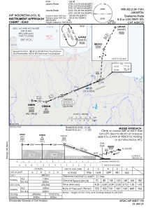
IAC chart of WIII
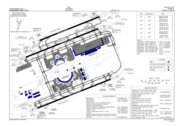
 ADC chart of WIII
 Satellite view of WIII
ADC chart of WIII
Satellite view of WIII
Sorry, we have no imagery here.
Sorry, we have no imagery here.
Sorry, we have no imagery here.
Sorry, we have no imagery here.
Sorry, we have no imagery here.
Sorry, we have no imagery here.


WIII - Jakarta / Soekarno Hatta Intl
Located in Jakarta, Indonesia
ICAO - WIII, IATA - CGK
Data provided by AirmateGeneral information
Coordinates: S6°7'25" E106°39'40"
Elevation is 34 feet MSL.
View others Airports in Banten
Operational data
Special qualification required
Current time UTC:
Current local time:
Weather
METAR: WIII 051200Z 27003KT 8000 SCT018 28/25 Q1009 NOSIG
TAF: TAF WIII 051100Z 0512/0618 26005KT 7000 SCT020 BECMG 0518/0520 5000 HZ BECMG 0600/0602 32013KT
Communications frequencies: [VIEW]
Runways:
| RWY identifier | QFU | Length (ft) | Width (ft) | Surface | LDA (ft) |
| 07R | 68° | 12008 | 197 | CON | |
| 25L | 248° | 12008 | 197 | CON | |
| 07L | 68° | 11811 | 197 | CON | |
| 25R | 248° | 11811 | 197 | CON | |
| 06 | 68° | 9843 | 197 | UNK | |
| 24 | 248° | 9843 | 197 | UNK |
Airport contact information
Address: Jakarta Indonesia
Satellite view of WIII
Sorry, we have no imagery here.
Sorry, we have no imagery here.
Sorry, we have no imagery here.
Sorry, we have no imagery here.
Sorry, we have no imagery here.
Sorry, we have no imagery here.