ADC chart of WI46
 Satellite view of WI46
Satellite view of WI46
Sorry, we have no imagery here.
Sorry, we have no imagery here.
Sorry, we have no imagery here.
Sorry, we have no imagery here.
Sorry, we have no imagery here.
Sorry, we have no imagery here.


WI46 - Fun-Air
Located in Van Dyne, United States
ICAO - WI46, IATA -
Data provided by AirmateGeneral information
Coordinates: N43°52'58" W88°32'24"
Elevation is 830 feet MSL.
Magnetic variation is -02° East View others Airports in Wisconsin
Operational data
Special qualification required
Current time UTC:
Current local time:
Weather at : KOSH - Wittman Rgnl ( 11 km )
METAR: KOSH 220653Z AUTO 29006KT 10SM BKN060 OVC070 08/07 A2990 RMK AO2 RAB03E17 SLP127 P0000 T00780067
Communications frequencies: [VIEW]
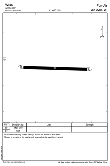
Runways:
| RWY identifier | QFU | Length (ft) | Width (ft) | Surface | LDA (ft) |
| 09 | 0° | 1407 | 60 | GRASS | |
| 27 | 0° | 1407 | 60 | GRASS |
Airport contact information
Address: Van Dyne United States
Satellite view of WI46
Sorry, we have no imagery here.
Sorry, we have no imagery here.
Sorry, we have no imagery here.
Sorry, we have no imagery here.
Sorry, we have no imagery here.
Sorry, we have no imagery here.