ADC chart of WI31
 Satellite view of WI31
Satellite view of WI31
Sorry, we have no imagery here.
Sorry, we have no imagery here.
Sorry, we have no imagery here.
Sorry, we have no imagery here.
Sorry, we have no imagery here.
Sorry, we have no imagery here.


WI31 - Minnesuing
Located in Lake Nebagamon, United States
ICAO - WI31, IATA -
Data provided by AirmateGeneral information
Coordinates: N46°24'37" W91°39'13"
Elevation is 1207 feet MSL.
Magnetic variation is 01° East View others Airports in Wisconsin
Operational data
Special qualification required
Current time UTC:
Current local time:
Weather at : KOLG - Solon Springs Muni ( 16 km )
METAR: KOLG 211935Z AUTO 01007KT 10SM SCT090 BKN110 10/02 A2996 RMK AO1
Communications frequencies: [VIEW]
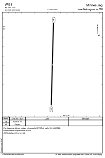
Runways:
| RWY identifier | QFU | Length (ft) | Width (ft) | Surface | LDA (ft) |
| 18 | 0° | 5300 | 75 | ASPH | |
| 36 | 0° | 5300 | 75 | ASPH |
Airport contact information
Address: Lake Nebagamon United States
Satellite view of WI31
Sorry, we have no imagery here.
Sorry, we have no imagery here.
Sorry, we have no imagery here.
Sorry, we have no imagery here.
Sorry, we have no imagery here.
Sorry, we have no imagery here.