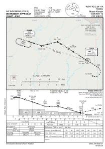
IAC chart of WAYY
 Satellite view of WAYY
Satellite view of WAYY
Sorry, we have no imagery here.
Sorry, we have no imagery here.
Sorry, we have no imagery here.
Sorry, we have no imagery here.
Sorry, we have no imagery here.
Sorry, we have no imagery here.


WAYY - Timika / Mozes Kilangin
Located in Timika, Indonesia
ICAO - , IATA - TIM
Data provided by AirmateGeneral information
Coordinates: S4°31'52" E136°52'60"
Elevation is 103 feet MSL.
View others Airports in Papua
Operational data
Special qualification required
Current time UTC:
Current local time:
Weather at : - ( 0 km )
METAR: YBHM 091948Z AUTO 13021G31KT 9999 // SCT029 BKN038 26/21 Q1013
Communications frequencies: [VIEW]
Runways:
| RWY identifier | QFU | Length (ft) | Width (ft) | Surface | LDA (ft) |
| 12 | 122° | 7841 | 148 | UNK | |
| 30 | 302° | 7841 | 148 | UNK |
Airport contact information
Address: Timika Indonesia
Satellite view of WAYY
Sorry, we have no imagery here.
Sorry, we have no imagery here.
Sorry, we have no imagery here.
Sorry, we have no imagery here.
Sorry, we have no imagery here.
Sorry, we have no imagery here.