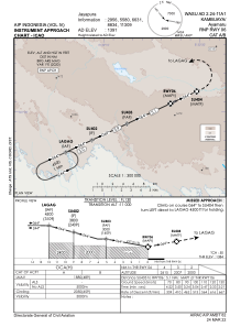
IAC chart of WASU
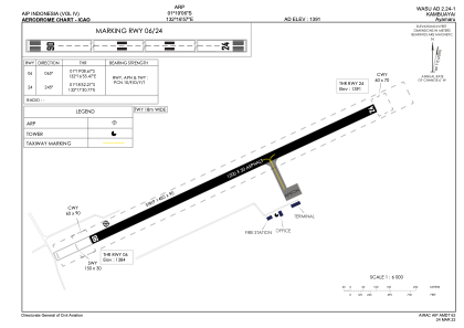
 ADC chart of WASU
 Satellite view of WASU
ADC chart of WASU
Satellite view of WASU
Sorry, we have no imagery here.
Sorry, we have no imagery here.
Sorry, we have no imagery here.
Sorry, we have no imagery here.
Sorry, we have no imagery here.
Sorry, we have no imagery here.


WASU - Kambuaya/Ayamaru
Located in Ayamaru, Indonesia
ICAO - , IATA - KBX
Data provided by AirmateGeneral information
Coordinates: S1°19'6" E132°16'57"
Elevation is 1391 feet MSL.
Magnetic variation is 1° East View others Airports in Irian Jaya
Operational data
Special qualification required
Current time UTC:
Current local time:
Weather at : - ( 0 km )
METAR: PAWG 091925Z VRB04KT 10SM -RA FEW007 BKN040 BKN060 05/03 A3009 RMK AO2 PNO $
Communications frequencies: [VIEW]
Runways:
| RWY identifier | QFU | Length (ft) | Width (ft) | Surface | LDA (ft) |
| 06 | 65° | 3937 | 98 | UNK | |
| 24 | 245° | 3937 | 98 | UNK |
Airport contact information
Address: Ayamaru Indonesia
Satellite view of WASU
Sorry, we have no imagery here.
Sorry, we have no imagery here.
Sorry, we have no imagery here.
Sorry, we have no imagery here.
Sorry, we have no imagery here.
Sorry, we have no imagery here.