ADC chart of WAPC
 Satellite view of WAPC
Satellite view of WAPC
Sorry, we have no imagery here.
Sorry, we have no imagery here.
Sorry, we have no imagery here.
Sorry, we have no imagery here.
Sorry, we have no imagery here.
Sorry, we have no imagery here.


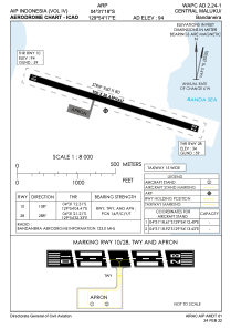
WAPC - Central Maluku / Bandaneira
Located in Banda, Indonesia
ICAO - WAPC, IATA - NDA
Data provided by AirmateGeneral information
Coordinates: S4°31'18" E129°54'17"
Elevation is 89 feet MSL.
View others Airports in Maluku
Operational data
Special qualification required
Current time UTC:
Current local time:
Weather at : - ( 0 km )
METAR: URMM 092231Z VRB01MPS 8000 -SHRA BKN004 OVC///CB 01/00 Q1013 R11/290150 NOSIG RMK MT OBSC OBST OBSC QFE732/0976
Communications frequencies: [VIEW]
Runways:
| RWY identifier | QFU | Length (ft) | Width (ft) | Surface | LDA (ft) |
| 10 | 108° | 2953 | 98 | UNK | |
| 28 | 288° | 2953 | 98 | UNK |
Airport contact information
Address: Banda Indonesia
Satellite view of WAPC
Sorry, we have no imagery here.
Sorry, we have no imagery here.
Sorry, we have no imagery here.
Sorry, we have no imagery here.
Sorry, we have no imagery here.
Sorry, we have no imagery here.