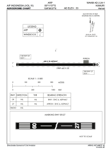
ADC chart of WAKM
 Satellite view of WAKM
Satellite view of WAKM
Sorry, we have no imagery here.
Sorry, we have no imagery here.
Sorry, we have no imagery here.
Sorry, we have no imagery here.
Sorry, we have no imagery here.
Sorry, we have no imagery here.


WAKM - Kamur / Asmat
Located in Kamur, Indonesia
ICAO - , IATA - KCD
Data provided by AirmateGeneral information
Coordinates: S6°11'7" E138°38'27"
Elevation is 33 feet MSL.
View others Airports in Papua
Operational data
Special qualification required
Current time UTC:
Current local time:
Weather at : - ( 0 km )
METAR: KJXI 120655Z AUTO 00000KT 10SM SCT080 SCT100 12/05 A3018 RMK AO2 T01150052
Communications frequencies: [VIEW]
Runways:
| RWY identifier | QFU | Length (ft) | Width (ft) | Surface | LDA (ft) |
| 09 | 0° | 1969 | 59 | UNK | |
| 27 | 0° | 1969 | 59 | UNK |
Airport contact information
Address: Kamur Indonesia
Satellite view of WAKM
Sorry, we have no imagery here.
Sorry, we have no imagery here.
Sorry, we have no imagery here.
Sorry, we have no imagery here.
Sorry, we have no imagery here.
Sorry, we have no imagery here.