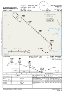
IAC chart of WAKJ
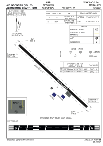
 ADC chart of WAKJ
 Satellite view of WAKJ
ADC chart of WAKJ
Satellite view of WAKJ
Sorry, we have no imagery here.
Sorry, we have no imagery here.
Sorry, we have no imagery here.
Sorry, we have no imagery here.
Sorry, we have no imagery here.
Sorry, we have no imagery here.


WAKJ - Merauke / Kimaam
Located in , Indonesia
ICAO - , IATA - KMM
Data provided by AirmateGeneral information
Coordinates: S7°58'45" E138°51'9"
Elevation is 14 feet MSL.
View others Airports in Papua
Operational data
Special qualification required
Current time UTC:
Current local time:
Weather at : - ( 0 km )
METAR: MMTG 120501Z RTD 31009KT 8SM SKC 22/14 A3012 RMK ISOL CI
Communications frequencies: [VIEW]
Runways:
| RWY identifier | QFU | Length (ft) | Width (ft) | Surface | LDA (ft) |
| 13 | 131° | 3018 | 75 | UNK | |
| 31 | 311° | 3018 | 75 | UNK |
Airport contact information
Address: Indonesia
Satellite view of WAKJ
Sorry, we have no imagery here.
Sorry, we have no imagery here.
Sorry, we have no imagery here.
Sorry, we have no imagery here.
Sorry, we have no imagery here.
Sorry, we have no imagery here.