ADC chart of WAJS
 Satellite view of WAJS
Satellite view of WAJS
Sorry, we have no imagery here.
Sorry, we have no imagery here.
Sorry, we have no imagery here.
Sorry, we have no imagery here.
Sorry, we have no imagery here.


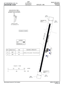
WAJS - Keerom / Senggeh
Located in Keerom, Indonesia
ICAO - WAJS, IATA - SEH
Data provided by AirmateGeneral information
Coordinates: S3°26'34" E140°46'42"
Elevation is 680 feet MSL.
View others Airports in Papua
Operational data
Special qualification required
Current time UTC:
Current local time:
Weather at : - ( 0 km )
METAR: ZMCK 091530Z 06004MPS CAVOK 03/M13 Q1003 NOSIG
Communications frequencies: [VIEW]
Runways:
| RWY identifier | QFU | Length (ft) | Width (ft) | Surface | LDA (ft) |
| 01 | 11° | 2953 | 75 | UNK | |
| 19 | 191° | 2953 | 75 | UNK |
Airport contact information
Address: Keerom Indonesia
Satellite view of WAJS
Sorry, we have no imagery here.
Sorry, we have no imagery here.
Sorry, we have no imagery here.
Sorry, we have no imagery here.
Sorry, we have no imagery here.