ADC chart of WAJE
 Satellite view of WAJE
Satellite view of WAJE
Sorry, we have no imagery here.
Sorry, we have no imagery here.
Sorry, we have no imagery here.
Sorry, we have no imagery here.
Sorry, we have no imagery here.
Sorry, we have no imagery here.


WAJE - Yuruf
Located in Amgotro, Indonesia
ICAO - WAJE, IATA - RUF
Data provided by AirmateGeneral information
Coordinates: S3°36'7" E140°54'23"
Elevation is 1844 feet MSL.
Magnetic variation is 3° East View others Airports in Papua
Operational data
Special qualification required
Current time UTC:
Current local time:
Weather at : - ( 0 km )
METAR: ZMUB 110000Z 34009MPS 6000 -SN BLSN OVC030 M09/M14 Q1014 NOSIG RMK QFE653.6 69 NW MO
Communications frequencies: [VIEW]
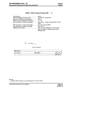
Runways:
| RWY identifier | QFU | Length (ft) | Width (ft) | Surface | LDA (ft) |
| 17 | 176° | 2290 | 87 | GRAS | |
| 35 | 356° | 2290 | 87 | GRAS |
Airport contact information
Address: Amgotro Indonesia
Satellite view of WAJE
Sorry, we have no imagery here.
Sorry, we have no imagery here.
Sorry, we have no imagery here.
Sorry, we have no imagery here.
Sorry, we have no imagery here.
Sorry, we have no imagery here.