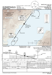
IAC chart of WAFW
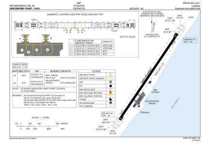
 ADC chart of WAFW
 Satellite view of WAFW

ADC chart of WAFW
Satellite view of WAFW
Sorry, we have no imagery here.
Sorry, we have no imagery here.
Sorry, we have no imagery here.
Sorry, we have no imagery here.
Sorry, we have no imagery here.
Sorry, we have no imagery here.


WAFW - Luwuk/Syukuran Aminuddin Amir
Located in Luwuk, Indonesia
ICAO - , IATA - LUW
Data provided by AirmateGeneral information
Coordinates: S1°2'26" E122°46'21"
Elevation is 62 feet MSL.
View others Airports in Sulawesi Tengah
Operational data
Special qualification required
Current time UTC:
Current local time:
Weather at : - ( 0 km )
METAR: KY70 020735Z AUTO 11011KT 10SM OVC110 M05/M09 A3020 RMK AO2
Communications frequencies: [VIEW]
Runways:
| RWY identifier | QFU | Length (ft) | Width (ft) | Surface | LDA (ft) |
| 04 | 35° | 7382 | 148 | UNK | |
| 22 | 215° | 7382 | 148 | UNK |
Airport contact information
Address: Luwuk Indonesia
Satellite view of WAFW
Sorry, we have no imagery here.
Sorry, we have no imagery here.
Sorry, we have no imagery here.
Sorry, we have no imagery here.
Sorry, we have no imagery here.
Sorry, we have no imagery here.