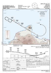
IAC chart of WAFU
 Satellite view of WAFU

Satellite view of WAFU
Sorry, we have no imagery here.
Sorry, we have no imagery here.
Sorry, we have no imagery here.
Sorry, we have no imagery here.
Sorry, we have no imagery here.
Sorry, we have no imagery here.


WAFU - Ampana / Tanjung Api
Located in Ampana, Indonesia
ICAO - , IATA -
Data provided by AirmateGeneral information
Coordinates: S0°51'50" E121°37'30"
Elevation is 107 feet MSL.
View others Airports in Sulawesi Tengah
Operational data
Special qualification required
Current time UTC:
Current local time:
Communications frequencies: [VIEW]
Runways:
| RWY identifier | QFU | Length (ft) | Width (ft) | Surface | LDA (ft) |
| 12 | 120° | 6923 | 98 | UNK | |
| 30 | 300° | 6923 | 98 | UNK |
Airport contact information
Address: Ampana Indonesia
Satellite view of WAFU
Sorry, we have no imagery here.
Sorry, we have no imagery here.
Sorry, we have no imagery here.
Sorry, we have no imagery here.
Sorry, we have no imagery here.
Sorry, we have no imagery here.