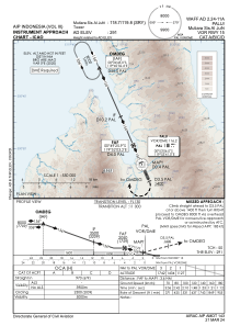
IAC chart of WAFF
 Satellite view of WAFF

Satellite view of WAFF
Sorry, we have no imagery here.
Sorry, we have no imagery here.
Sorry, we have no imagery here.
Sorry, we have no imagery here.
Sorry, we have no imagery here.
Sorry, we have no imagery here.


WAFF - Palu / Mutiara Sis Al-Jufri
Located in Palu, Indonesia
ICAO - , IATA - PLW
Data provided by AirmateGeneral information
Coordinates: S0°55'50" E119°54'37"
Elevation is 288 feet MSL.
View others Airports in Sulawesi Tengah
Operational data
Special qualification required
Current time UTC:
Current local time:
Weather at : - ( 0 km )
METAR: CYQV 020837Z AUTO 29019G24KT 1 3/4SM -SN BKN025 BKN041 BKN100 OVC120 M16/M18 A2977 RMK SLP131
Communications frequencies: [VIEW]
Runways:
| RWY identifier | QFU | Length (ft) | Width (ft) | Surface | LDA (ft) |
| 15 | 156° | 8202 | 148 | UNK | |
| 33 | 336° | 8202 | 148 | UNK |
Airport contact information
Address: Palu Indonesia
Satellite view of WAFF
Sorry, we have no imagery here.
Sorry, we have no imagery here.
Sorry, we have no imagery here.
Sorry, we have no imagery here.
Sorry, we have no imagery here.
Sorry, we have no imagery here.