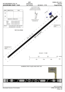
ADC chart of WABA
 Satellite view of WABA
Satellite view of WABA
Sorry, we have no imagery here.
Sorry, we have no imagery here.
Sorry, we have no imagery here.
Sorry, we have no imagery here.
Sorry, we have no imagery here.
Sorry, we have no imagery here.


WABA - Deiyai/Waghete Baru
Located in , Indonesia
ICAO - , IATA -
Data provided by AirmateGeneral information
Coordinates: S4°3'33" E136°16'55"
Elevation is 1779 feet MSL.
Magnetic variation is 2° East View others Airports in Papua
Operational data
Special qualification required
Current time UTC:
Current local time:
Weather at : - ( 0 km )
METAR: CYCY 110651Z AUTO 32022G31KT 3SM BLSN CLR M13/M16 A2945 RMK PRESRR SLP979
Communications frequencies: [VIEW]
Runways:
| RWY identifier | QFU | Length (ft) | Width (ft) | Surface | LDA (ft) |
| 04 | 0° | 4593 | 75 | UNK | |
| 22 | 0° | 4593 | 75 | UNK |
Airport contact information
Address: Indonesia
Satellite view of WABA
Sorry, we have no imagery here.
Sorry, we have no imagery here.
Sorry, we have no imagery here.
Sorry, we have no imagery here.
Sorry, we have no imagery here.
Sorry, we have no imagery here.