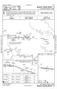
IAC chart of W96
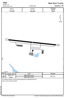
 ADC chart of W96
 Satellite view of W96
ADC chart of W96
Satellite view of W96
Sorry, we have no imagery here.
Sorry, we have no imagery here.
Sorry, we have no imagery here.
Sorry, we have no imagery here.
Sorry, we have no imagery here.
Sorry, we have no imagery here.


W96 - New Kent County
Located in Quinton, United States
ICAO - W96, IATA -
Data provided by AirmateGeneral information
Coordinates: N37°30'12" W77°7'36"
Elevation is 121 feet MSL.
Magnetic variation is -10° East View others Airports in Virginia
Operational data
Special qualification required
Current time UTC:
Current local time:
Weather at : KRIC - Richmond Intl ( 17 km )
METAR: KRIC 011554Z 36010KT 10SM CLR 14/02 A3004 RMK AO2 SLP178 T01390022
TAF: KRIC 011120Z 0112/0212 35012G20KT P6SM SKC FM011600 36010G18KT P6SM SKC FM012000 02008KT P6SM SKC FM020000 08003KT P6SM SKC
Communications frequencies: [VIEW]
Runways:
| RWY identifier | QFU | Length (ft) | Width (ft) | Surface | LDA (ft) |
| 11 | 96° | 3602 | 75 | ASPH | |
| 29 | 276° | 3602 | 75 | ASPH |
Airport contact information
Address: Quinton United States
Satellite view of W96
Sorry, we have no imagery here.
Sorry, we have no imagery here.
Sorry, we have no imagery here.
Sorry, we have no imagery here.
Sorry, we have no imagery here.
Sorry, we have no imagery here.