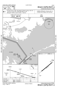
IAC chart of W95
 Satellite view of W95
Satellite view of W95
Sorry, we have no imagery here.
Sorry, we have no imagery here.
Sorry, we have no imagery here.
Sorry, we have no imagery here.
Sorry, we have no imagery here.
Sorry, we have no imagery here.


W95 - Ocracoke Island
Located in Ocracoke, United States
ICAO - W95, IATA -
Data provided by AirmateGeneral information
Coordinates: N35°6'4" W75°57'57"
Elevation is 4 feet MSL.
Magnetic variation is -09° East View others Airports in North Carolina
Operational data
Special qualification required
Current time UTC:
Current local time:
Weather at : KHSE - Billy Mitchell ( 35 km )
METAR: KHSE 021351Z AUTO 08011KT CLR 19/11 A3034 RMK AO2 SLP273 T01890106 $
Communications frequencies: [VIEW]
Runways:
| RWY identifier | QFU | Length (ft) | Width (ft) | Surface | LDA (ft) |
| 06 | 50° | 2998 | 60 | ASPH | |
| 24 | 230° | 2998 | 60 | ASPH | |
| H1 | 0° | 0 | 0 | UNK |
Airport contact information
Address: Ocracoke United States
Satellite view of W95
Sorry, we have no imagery here.
Sorry, we have no imagery here.
Sorry, we have no imagery here.
Sorry, we have no imagery here.
Sorry, we have no imagery here.
Sorry, we have no imagery here.