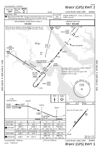
IAC chart of W94
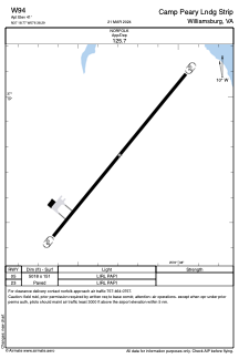
 ADC chart of W94
 Satellite view of W94
ADC chart of W94
Satellite view of W94
Sorry, we have no imagery here.
Sorry, we have no imagery here.
Sorry, we have no imagery here.
Sorry, we have no imagery here.
Sorry, we have no imagery here.
Sorry, we have no imagery here.


W94 - Camp Peary Lndg Strip
Located in Williamsburg, United States
ICAO - W94, IATA -
Data provided by AirmateGeneral information
Coordinates: N37°18'46" W76°38'18"
Elevation is 41 feet MSL.
Magnetic variation is -11° East View others Airports in Virginia
Operational data
Special qualification required
Current time UTC:
Current local time:
Weather at : KJGG - Waltrip Williamsburg Exec Airport ( 11 km )
METAR: KJGG 011355Z AUTO 36012KT 10SM CLR 12/04 A2998 RMK AO2 T01160038 $
Communications frequencies: [VIEW]
Runways:
| RWY identifier | QFU | Length (ft) | Width (ft) | Surface | LDA (ft) |
| 05 | 0° | 5018 | 151 | ASPH | |
| 23 | 0° | 5018 | 151 | ASPH |
Airport contact information
Address: Williamsburg United States
Satellite view of W94
Sorry, we have no imagery here.
Sorry, we have no imagery here.
Sorry, we have no imagery here.
Sorry, we have no imagery here.
Sorry, we have no imagery here.
Sorry, we have no imagery here.