ADC chart of W48
 Satellite view of W48
Satellite view of W48
Sorry, we have no imagery here.
Sorry, we have no imagery here.
Sorry, we have no imagery here.
Sorry, we have no imagery here.
Sorry, we have no imagery here.
Sorry, we have no imagery here.


W48 - Essex Skypark
Located in Baltimore, United States
ICAO - W48, IATA -
Data provided by AirmateGeneral information
Coordinates: N39°15'45" W76°25'56"
Elevation is 14 feet MSL.
Magnetic variation is -10° East View others Airports in Maryland
Operational data
Special qualification required
Current time UTC:
Current local time:
Weather at : KMTN - Martin State ( 7 km )
METAR: KMTN 050449Z AUTO 00000KT 10SM BKN048 17/08 A3027 RMK AO2
TAF: KMTN 042345Z 0500/0524 31003KT P6SM SCT040 BKN060 FM050400 06003KT P6SM BKN040 FM050900 10004KT 6SM -SHRA BR OVC025 FM051400 11006KT 6SM BR BKN008 OVC015 FM051700 14007KT 6SM BR OVC008
Communications frequencies: [VIEW]
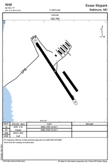
Runways:
| RWY identifier | QFU | Length (ft) | Width (ft) | Surface | LDA (ft) |
| 16 | 147° | 2081 | 30 | ASPH | |
| 34 | 327° | 2081 | 30 | ASPH | |
| 16W | 0° | 3000 | 300 | WATER | |
| 34W | 0° | 3000 | 300 | WATER |
Airport contact information
Address: Baltimore United States
Satellite view of W48
Sorry, we have no imagery here.
Sorry, we have no imagery here.
Sorry, we have no imagery here.
Sorry, we have no imagery here.
Sorry, we have no imagery here.
Sorry, we have no imagery here.