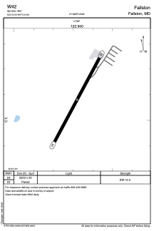
ADC chart of W42
 Satellite view of W42
Satellite view of W42
Sorry, we have no imagery here.
Sorry, we have no imagery here.
Sorry, we have no imagery here.
Sorry, we have no imagery here.
Sorry, we have no imagery here.
Sorry, we have no imagery here.


W42 - Fallston
Located in Fallston, United States
ICAO - W42, IATA -
Data provided by AirmateGeneral information
Coordinates: N39°30'5" W76°24'41"
Elevation is 460 feet MSL.
Magnetic variation is -10° East View others Airports in Maryland
Operational data
Special qualification required
Current time UTC:
Current local time:
Weather at : KMTN - Martin State ( 20 km )
METAR: KMTN 051154Z 07004KT 10SM OVC029 16/11 A3021
TAF: KMTN 051139Z 0512/0612 06003KT P6SM VCSH BKN025 OVC035 FM051500 11005KT P6SM BKN008 OVC015 FM052200 08004KT P6SM OVC015 FM060000 07004KT 5SM BR OVC011 WS020/21035KT PROB30 0600/0604 3SM -SHRA FM060500 09003KT 5SM BR BKN008 WS020/21035KT FM060800 16004KT 4SM BR BKN020
Communications frequencies: [VIEW]
Runways:
| RWY identifier | QFU | Length (ft) | Width (ft) | Surface | LDA (ft) |
| 04 | 28° | 2200 | 50 | ASPH | |
| 22 | 208° | 2200 | 50 | ASPH |
Airport contact information
Address: Fallston United States
Satellite view of W42
Sorry, we have no imagery here.
Sorry, we have no imagery here.
Sorry, we have no imagery here.
Sorry, we have no imagery here.
Sorry, we have no imagery here.
Sorry, we have no imagery here.