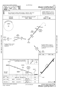
IAC chart of W40
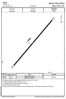
 ADC chart of W40
 Satellite view of W40
ADC chart of W40
Satellite view of W40
Sorry, we have no imagery here.
Sorry, we have no imagery here.
Sorry, we have no imagery here.
Sorry, we have no imagery here.
Sorry, we have no imagery here.
Sorry, we have no imagery here.


W40 - Mount Olive Muni
Located in Mount Olive, United States
ICAO - W40, IATA -
Data provided by AirmateGeneral information
Coordinates: N35°13'17" W78°2'19"
Elevation is 167 feet MSL.
Magnetic variation is -09° East View others Airports in North Carolina
Operational data
Special qualification required
Current time UTC:
Current local time:
Weather at : KGSB - Seymour Johnson Afb ( 15 km )
METAR: KGSB 021255Z 10009KT 10SM BKN030 14/09 A3028 RMK AO2A SLP257 T01400090 $
Communications frequencies: [VIEW]
Runways:
| RWY identifier | QFU | Length (ft) | Width (ft) | Surface | LDA (ft) |
| 05 | 40° | 5254 | 75 | ASPH | |
| 23 | 220° | 5254 | 75 | ASPH |
Airport contact information
Address: Mount Olive United States
Other aviation service providers
Flight schools

Satellite view of W40
Sorry, we have no imagery here.
Sorry, we have no imagery here.
Sorry, we have no imagery here.
Sorry, we have no imagery here.
Sorry, we have no imagery here.
Sorry, we have no imagery here.