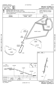
IAC chart of W31
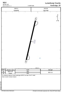
 ADC chart of W31
 Satellite view of W31
ADC chart of W31
Satellite view of W31
Sorry, we have no imagery here.
Sorry, we have no imagery here.
Sorry, we have no imagery here.
Sorry, we have no imagery here.
Sorry, we have no imagery here.
Sorry, we have no imagery here.


W31 - Lunenburg County
Located in Kenbridge, United States
ICAO - W31, IATA -
Data provided by AirmateGeneral information
Coordinates: N36°57'37" W78°11'6"
Elevation is 526 feet MSL.
Magnetic variation is -10° East View others Airports in Virginia
Operational data
Special qualification required
Current time UTC:
Current local time:
Weather at : KBKT - Allan C Perkinson/Blackstone Aaf ( 24 km )
METAR: KBKT 011455Z AUTO 34010KT 10SM CLR 15/05 A3001 RMK AO2 SLP164 T01520046 52026
Communications frequencies: [VIEW]
Runways:
| RWY identifier | QFU | Length (ft) | Width (ft) | Surface | LDA (ft) |
| 02 | 13° | 3000 | 50 | ASPH | |
| 20 | 193° | 3000 | 50 | ASPH |
Airport contact information
Address: Kenbridge United States
Satellite view of W31
Sorry, we have no imagery here.
Sorry, we have no imagery here.
Sorry, we have no imagery here.
Sorry, we have no imagery here.
Sorry, we have no imagery here.
Sorry, we have no imagery here.