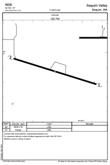
ADC chart of W28
 Satellite view of W28
Satellite view of W28
Sorry, we have no imagery here.
Sorry, we have no imagery here.
Sorry, we have no imagery here.
Sorry, we have no imagery here.
Sorry, we have no imagery here.
Sorry, we have no imagery here.


W28 - Sequim Valley
Located in Sequim, United States
ICAO - W28, IATA -
Data provided by AirmateGeneral information
Coordinates: N48°5'53" W123°11'17"
Elevation is 151 feet MSL.
Magnetic variation is 21° East View others Airports in Washington
Operational data
Special qualification required
Current time UTC:
Current local time:
Weather at : KNOW - Port Angeles Cgas ( 17 km )
METAR: KNOW 051035Z AUTO 00000KT 10SM CLR 06/06 A3030 RMK AO2 T00630059
Communications frequencies: [VIEW]
Runways:
| RWY identifier | QFU | Length (ft) | Width (ft) | Surface | LDA (ft) |
| 09 | 0° | 3508 | 40 | ASPH | |
| 27 | 0° | 3508 | 40 | ASPH |
Airport contact information
Address: Sequim United States
Satellite view of W28
Sorry, we have no imagery here.
Sorry, we have no imagery here.
Sorry, we have no imagery here.
Sorry, we have no imagery here.
Sorry, we have no imagery here.
Sorry, we have no imagery here.