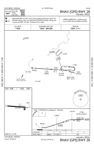
IAC chart of W24
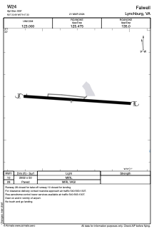
 ADC chart of W24
 Satellite view of W24
ADC chart of W24
Satellite view of W24
Sorry, we have no imagery here.
Sorry, we have no imagery here.
Sorry, we have no imagery here.
Sorry, we have no imagery here.
Sorry, we have no imagery here.


W24 - Falwell
Located in Lynchburg, United States
ICAO - W24, IATA -
Data provided by AirmateGeneral information
Coordinates: N37°22'41" W79°7'20"
Elevation is 939 feet MSL.
Magnetic variation is -09° East View others Airports in Virginia
Operational data
Special qualification required
Current time UTC:
Current local time:
Weather at : KLYH - Lynchburg Rgnl/Preston Glenn Fld ( 9 km )
METAR: KLYH 011454Z VRB04KT 10SM CLR 13/02 A3004 RMK AO2 SLP168 T01330017 53022
TAF: KLYH 011120Z 0112/0212 32007KT P6SM SCT040 FM011800 06004KT P6SM SKC FM021000 09005KT P6SM BKN025
Communications frequencies: [VIEW]
Runways:
| RWY identifier | QFU | Length (ft) | Width (ft) | Surface | LDA (ft) |
| 10 | 0° | 2932 | 50 | ASPH | |
| 28 | 0° | 2932 | 50 | ASPH |
Airport contact information
Address: Lynchburg United States
Satellite view of W24
Sorry, we have no imagery here.
Sorry, we have no imagery here.
Sorry, we have no imagery here.
Sorry, we have no imagery here.
Sorry, we have no imagery here.