ADC chart of W20
 Satellite view of W20
Satellite view of W20
Sorry, we have no imagery here.
Sorry, we have no imagery here.
Sorry, we have no imagery here.
Sorry, we have no imagery here.
Sorry, we have no imagery here.
Sorry, we have no imagery here.


W20 - Moses Lake Muni
Located in Moses Lake, United States
ICAO - W20, IATA -
Data provided by AirmateGeneral information
Coordinates: N47°8'31" W119°14'16"
Elevation is 1205 feet MSL.
Magnetic variation is 19° East View others Airports in Washington
Operational data
Special qualification required
Current time UTC:
Current local time:
Weather at : KMWH - Grant County Intl ( 10 km )
METAR: KMWH 051252Z 34007KT 10SM CLR M01/M02 A3038 RMK AO2 SLP296 T10111022
TAF: KMWH 051120Z 0512/0612 02004KT P6SM SCT250 FM052000 21005KT P6SM SCT200 FM060600 03004KT P6SM BKN250
Communications frequencies: [VIEW]
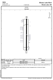
Runways:
| RWY identifier | QFU | Length (ft) | Width (ft) | Surface | LDA (ft) |
| 16 | 0° | 2513 | 50 | ASPH | |
| 34 | 0° | 2513 | 50 | ASPH |
Airport contact information
Address: Moses Lake United States
Other aviation service providers
Flight schools

Satellite view of W20
Sorry, we have no imagery here.
Sorry, we have no imagery here.
Sorry, we have no imagery here.
Sorry, we have no imagery here.
Sorry, we have no imagery here.
Sorry, we have no imagery here.