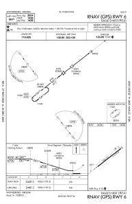
IAC chart of W13
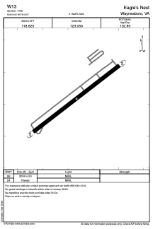
 ADC chart of W13
 Satellite view of W13
ADC chart of W13
Satellite view of W13
Sorry, we have no imagery here.
Sorry, we have no imagery here.
Sorry, we have no imagery here.
Sorry, we have no imagery here.
Sorry, we have no imagery here.
Sorry, we have no imagery here.


W13 - Eagle's Nest
Located in Waynesboro, United States
ICAO - W13, IATA -
Data provided by AirmateGeneral information
Coordinates: N38°4'37" W78°56'40"
Elevation is 1436 feet MSL.
Magnetic variation is -09° East View others Airports in Virginia
Operational data
Special qualification required
Current time UTC:
Current local time:
Weather at : KSHD - Shenandoah Valley Rgnl ( 21 km )
METAR: KSHD 011515Z AUTO 06003KT 10SM CLR 10/01 A3008 RMK AO2 T00950007
Communications frequencies: [VIEW]
Runways:
| RWY identifier | QFU | Length (ft) | Width (ft) | Surface | LDA (ft) |
| 06 | 0° | 2004 | 50 | ASPH | |
| 24 | 0° | 2004 | 50 | ASPH |
Airport contact information
Address: Waynesboro United States
Other aviation service providers
Flight schools

Eagle's Nest Flight Services, Llc
Eagle's Nest Flight Services, Llc
jtrissel@eaglesnest.aero+1(540)943-4447
Satellite view of W13
Sorry, we have no imagery here.
Sorry, we have no imagery here.
Sorry, we have no imagery here.
Sorry, we have no imagery here.
Sorry, we have no imagery here.
Sorry, we have no imagery here.