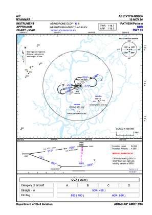
IAC chart of VYPN
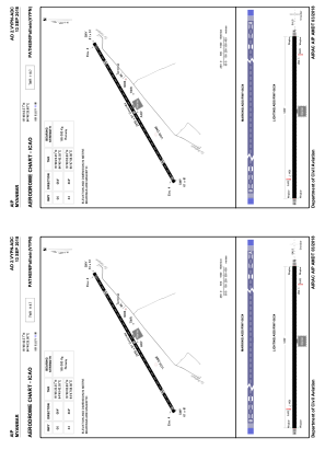
 ADC chart of VYPN
 Satellite view of VYPN

ADC chart of VYPN
Satellite view of VYPN
Sorry, we have no imagery here.
Sorry, we have no imagery here.
Sorry, we have no imagery here.
Sorry, we have no imagery here.
Sorry, we have no imagery here.
Sorry, we have no imagery here.


VYPN - Pathein
Located in Pathein, Myanmar
ICAO - VYPN, IATA - BSX
Data provided by AirmateGeneral information
Coordinates: N16°48'44" E94°46'26"
Elevation is 13 feet MSL.
View others Airports in Ayeyarwady Division
Operational data
Special qualification required
Current time UTC:
Current local time:
Weather at : - ( 0 km )
METAR: PKWA 241140Z AUTO 08011KT 10SM CLR 28/24 A2991 RMK AO2 T02770243
Communications frequencies: [VIEW]
Runways:
| RWY identifier | QFU | Length (ft) | Width (ft) | Surface | LDA (ft) |
| 06 | 64° | 9301 | 200 | CON | |
| 24 | 244° | 9301 | 200 | CON |
Airport contact information
Address: Pathein Myanmar
Satellite view of VYPN
Sorry, we have no imagery here.
Sorry, we have no imagery here.
Sorry, we have no imagery here.
Sorry, we have no imagery here.
Sorry, we have no imagery here.
Sorry, we have no imagery here.