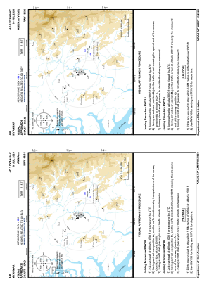
VAC chart of VYAN
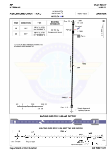
 ADC chart of VYAN
 Satellite view of VYAN
ADC chart of VYAN
Satellite view of VYAN
Sorry, we have no imagery here.
Sorry, we have no imagery here.
Sorry, we have no imagery here.
Sorry, we have no imagery here.
Sorry, we have no imagery here.
Sorry, we have no imagery here.


VYAN - Ann
Located in , Myanmar
ICAO - VYAN, IATA - VBA
Data provided by AirmateGeneral information
Coordinates: N19°46'9" E94°1'34"
Elevation is 53 feet MSL.
View others Airports in Rakhine State
Operational data
Special qualification required
Current time UTC:
Current local time:
Weather at : - ( 0 km )
METAR: UIBB 111112Z 17004MPS 130V210 1900 R30/1500N SHSN OVC013CB M04/M06 Q1021 R30/250150 NOSIG RMK QFE723/0964
Communications frequencies: [VIEW]
Runways:
| RWY identifier | QFU | Length (ft) | Width (ft) | Surface | LDA (ft) |
| 18 | 181° | 8501 | 98 | CON | |
| 36 | 1° | 8501 | 98 | CON |
Airport contact information
Address: Myanmar
Satellite view of VYAN
Sorry, we have no imagery here.
Sorry, we have no imagery here.
Sorry, we have no imagery here.
Sorry, we have no imagery here.
Sorry, we have no imagery here.
Sorry, we have no imagery here.