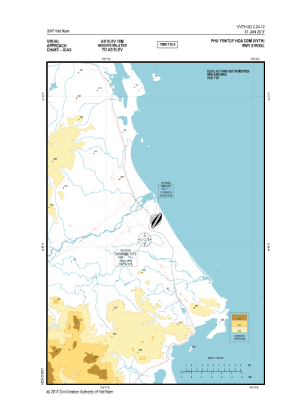
VAC chart of VVTH
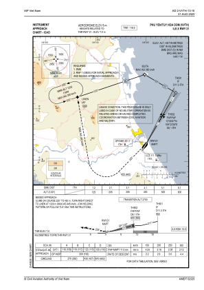
 IAC chart of VVTH
 Satellite view of VVTH
IAC chart of VVTH
Satellite view of VVTH
Sorry, we have no imagery here.
Sorry, we have no imagery here.
Sorry, we have no imagery here.
Sorry, we have no imagery here.
Sorry, we have no imagery here.
Sorry, we have no imagery here.


VVTH - Dong Tac Airport
Located in Tuy Hoa, Viet Nam
ICAO - VVTH, IATA - TBB
Data provided by AirmateGeneral information
Coordinates: N13°2'32" E109°19'49"
Elevation is 26 feet MSL.
View others Airports in Vinh Long
Operational data
Special qualification required
Current time UTC:
Current local time:
Weather at : - ( 0 km )
METAR: KEFD 060754Z 31012G18KT 7SM OVC012 13/11 A2995 RMK LTG DSNT E-S
Communications frequencies: [VIEW]
Runways:
| RWY identifier | QFU | Length (ft) | Width (ft) | Surface | LDA (ft) |
| 03 | 30° | 9514 | 148 | UNK | |
| 21 | 210° | 9514 | 148 | UNK |
Airport contact information
Address: Tuy Hoa Viet Nam
Satellite view of VVTH
Sorry, we have no imagery here.
Sorry, we have no imagery here.
Sorry, we have no imagery here.
Sorry, we have no imagery here.
Sorry, we have no imagery here.
Sorry, we have no imagery here.