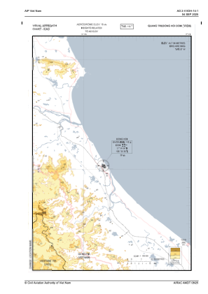
VAC chart of VVDH
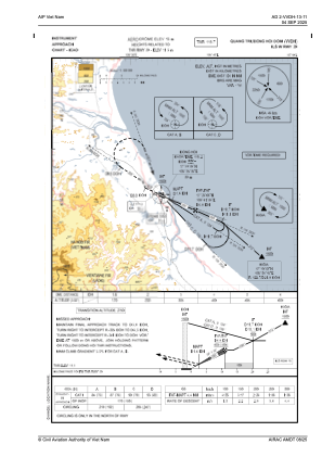
 IAC chart of VVDH
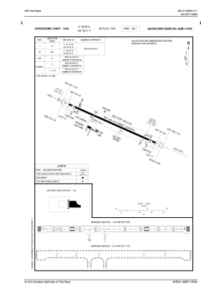
 ADC chart of VVDH
 Satellite view of VVDH
IAC chart of VVDHADC chart of VVDH
Satellite view of VVDH
Sorry, we have no imagery here.
Sorry, we have no imagery here.
Sorry, we have no imagery here.
Sorry, we have no imagery here.
Sorry, we have no imagery here.
Sorry, we have no imagery here.


VVDH - Quang Binh/Dong Hoi
Located in Dong Hoi, Viet Nam
ICAO - , IATA -
Data provided by AirmateGeneral information
Coordinates: N17°30'55" E106°35'27"
Elevation is 59 feet MSL.
View others Airports in Quang Binh
Operational data
Special qualification required
Current time UTC:
Current local time:
Weather at : - ( 0 km )
METAR: PKWA 060840Z AUTO 07012KT 10SM CLR 26/24 A2992 RMK AO2 T02640242
Communications frequencies: [VIEW]
Runways:
| RWY identifier | QFU | Length (ft) | Width (ft) | Surface | LDA (ft) |
| 11 | 114° | 7874 | 148 | UNK | |
| 29 | 294° | 7874 | 148 | UNK |
Airport contact information
Address: Dong Hoi Viet Nam
Satellite view of VVDH
Sorry, we have no imagery here.
Sorry, we have no imagery here.
Sorry, we have no imagery here.
Sorry, we have no imagery here.
Sorry, we have no imagery here.
Sorry, we have no imagery here.