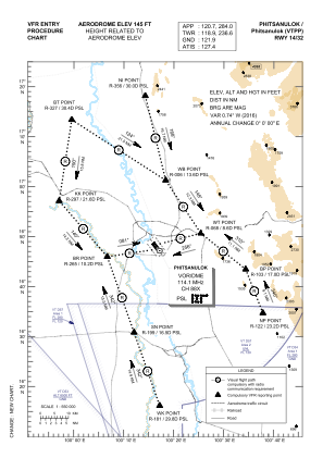
VAC chart of VTPP
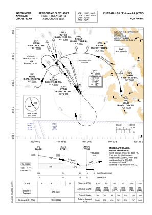
 IAC chart of VTPP
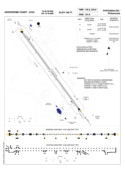
 ADC chart of VTPP
 Satellite view of VTPP
IAC chart of VTPPADC chart of VTPP
Satellite view of VTPP
Sorry, we have no imagery here.
Sorry, we have no imagery here.
Sorry, we have no imagery here.
Sorry, we have no imagery here.
Sorry, we have no imagery here.
Sorry, we have no imagery here.


VTPP - Phitsanulok / Phitsanulok Airport
Located in Phitsanulok, Thailand
ICAO - VTPP, IATA - PHS
Data provided by AirmateGeneral information
Coordinates: N16°46'59" E100°16'45"
Elevation is 145 feet MSL.
View others Airports in Phitsanulok Province
Operational data
Special qualification required
Current time UTC:
Current local time:
Weather
METAR: VTPP 101100Z 19005KT 9999 FEW030 33/21 Q1004 NOSIG
TAF: TAF VTPP 100500Z 1006/1106 15005KT 9999 FEW035 TEMPO 1009/1015 -TSRA FEW025CB SCT030
Communications frequencies: [VIEW]
Runways:
| RWY identifier | QFU | Length (ft) | Width (ft) | Surface | LDA (ft) |
| 14 | 144° | 9843 | 148 | ASP | |
| 32 | 324° | 9843 | 148 | ASP |
Airport contact information
Address: Phitsanulok Thailand
Satellite view of VTPP
Sorry, we have no imagery here.
Sorry, we have no imagery here.
Sorry, we have no imagery here.
Sorry, we have no imagery here.
Sorry, we have no imagery here.
Sorry, we have no imagery here.