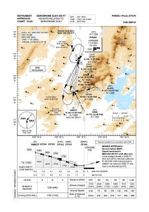
IAC chart of VTCP
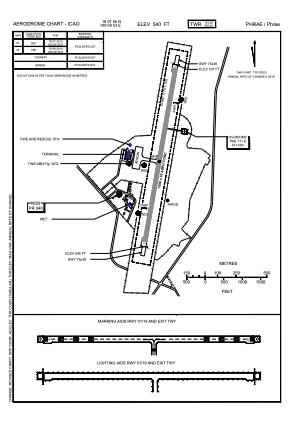
 ADC chart of VTCP
 Satellite view of VTCP
ADC chart of VTCP
Satellite view of VTCP
Sorry, we have no imagery here.
Sorry, we have no imagery here.
Sorry, we have no imagery here.
Sorry, we have no imagery here.
Sorry, we have no imagery here.
Sorry, we have no imagery here.


VTCP - Phrae / Phrae Airport
Located in Phrae, Thailand
ICAO - VTCP, IATA - PRH
Data provided by AirmateGeneral information
Coordinates: N18°7'56" E100°9'53"
Elevation is 538 feet MSL.
View others Airports in Phrae Province
Operational data
Special qualification required
Current time UTC:
Current local time:
Weather
METAR: VTCP 090900Z 13005KT 090V220 9999 SCT040 39/20 Q1005 NOSIG
TAF: TAF VTCP 090500Z 0906/1006 24005KT 9999 FEW030 TEMPO 0910/0914 29015G25KT 4000 TSRA FEW020CB BKN030
Communications frequencies: [VIEW]
Runways:
| RWY identifier | QFU | Length (ft) | Width (ft) | Surface | LDA (ft) |
| 01 | 5° | 4921 | 98 | ASP | |
| 19 | 185° | 4921 | 98 | ASP |
Airport contact information
Address: Phrae Thailand
Satellite view of VTCP
Sorry, we have no imagery here.
Sorry, we have no imagery here.
Sorry, we have no imagery here.
Sorry, we have no imagery here.
Sorry, we have no imagery here.
Sorry, we have no imagery here.