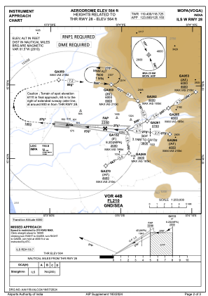
IAC chart of VOGA
 Satellite view of VOGA
Satellite view of VOGA
Sorry, we have no imagery here.
Sorry, we have no imagery here.
Sorry, we have no imagery here.
Sorry, we have no imagery here.
Sorry, we have no imagery here.
Sorry, we have no imagery here.


VOGA - Manohar International Airport-Mopa, Goa
Located in Mopa, India
ICAO - , IATA - GOX
Data provided by AirmateGeneral information
Coordinates: N15°44'33" E73°52'1"
Elevation is 564 feet MSL.
View others Airports in Goa
Operational data
Special qualification required
Current time UTC:
Current local time:
Weather at : VOGO - Goa International Airport, Dabolim, Goa (Navy) ( 40 km )
METAR: VOGO 092330Z 07005KT 6000 FEW020 27/21 Q1008 NOSIG
TAF: TAF VOGO 092300Z 1000/1106 06006KT 6000 FEW020 TEMPO 1000/1004 VRB02KT 4000 BR BECMG 1005/1006 27010KT FEW020 SCT070 TEMPO 1013/1017 09010G20KT 4000 -TSRA/RA FEW010 FEW025CB SCT030 BECMG 1018/1020 08006KT FEW020 TEMPO 1100/1104 4000 BR BECMG 1105/1106 27010KT
Communications frequencies: [VIEW]
Runways:
| RWY identifier | QFU | Length (ft) | Width (ft) | Surface | LDA (ft) |
| 10 | 95° | 11483 | 148 | UNK | |
| 28 | 275° | 11483 | 148 | UNK |
Airport contact information
Address: Mopa India
Satellite view of VOGA
Sorry, we have no imagery here.
Sorry, we have no imagery here.
Sorry, we have no imagery here.
Sorry, we have no imagery here.
Sorry, we have no imagery here.
Sorry, we have no imagery here.