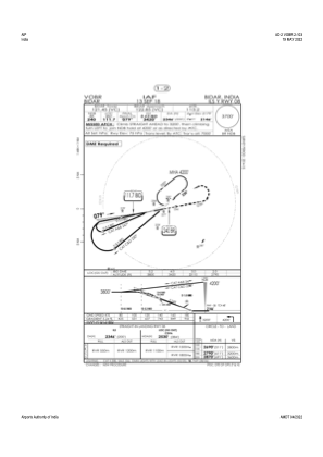
IAC chart of VOBR
 Satellite view of VOBR
Satellite view of VOBR
Sorry, we have no imagery here.
Sorry, we have no imagery here.
Sorry, we have no imagery here.
Sorry, we have no imagery here.
Sorry, we have no imagery here.
Sorry, we have no imagery here.


VOBR - Bidar/Indian Air Force
Located in Bidar, India
ICAO - VOBR, IATA - IXX
Data provided by AirmateGeneral information
Coordinates: N17°54'32" E77°28'55"
Elevation is 2178 feet MSL.
View others Airports in Karnataka
Operational data
Special qualification required
Current time UTC:
Current local time:
Weather at : - ( 0 km )
METAR: KY19 100715Z AUTO 30015KT 10SM CLR 05/04 A3010 RMK AO2
Communications frequencies: [VIEW]
Runways:
| RWY identifier | QFU | Length (ft) | Width (ft) | Surface | LDA (ft) |
| 02 | 18° | 9199 | 148 | ASP | |
| 20 | 198° | 9199 | 148 | ASP | |
| 08 | 78° | 8999 | 148 | ASP | |
| 26 | 258° | 8999 | 148 | ASP |
Airport contact information
Address: Bidar India
Satellite view of VOBR
Sorry, we have no imagery here.
Sorry, we have no imagery here.
Sorry, we have no imagery here.
Sorry, we have no imagery here.
Sorry, we have no imagery here.
Sorry, we have no imagery here.