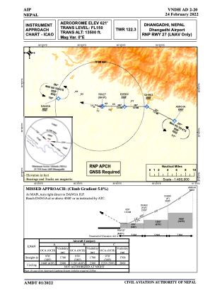
IAC chart of VNDH
 Satellite view of VNDH
Satellite view of VNDH
Sorry, we have no imagery here.
Sorry, we have no imagery here.
Sorry, we have no imagery here.
Sorry, we have no imagery here.
Sorry, we have no imagery here.
Sorry, we have no imagery here.


VNDH - Dhangadhi
Located in Dhangadhi, Nepal
ICAO - VNDH, IATA - DHI
Data provided by AirmateGeneral information
Coordinates: N28°45'16" E80°34'59"
Elevation is 621 feet MSL.
View others Airports in Bheri
Operational data
Special qualification required
Current time UTC:
Current local time:
Weather at : - ( 0 km )
METAR: UHMA 091358Z 01003MPS CAVOK M16/M18 Q1011 R02/////// NOSIG RMK MID 02003MPS END R02/35003MPS QFE755/1006
Communications frequencies: [VIEW]
Runways:
| RWY identifier | QFU | Length (ft) | Width (ft) | Surface | LDA (ft) |
| 09 | 89° | 5906 | 98 | UNK | |
| 27 | 269° | 5906 | 98 | UNK |
Airport contact information
Address: Dhangadhi Nepal
Satellite view of VNDH
Sorry, we have no imagery here.
Sorry, we have no imagery here.
Sorry, we have no imagery here.
Sorry, we have no imagery here.
Sorry, we have no imagery here.
Sorry, we have no imagery here.