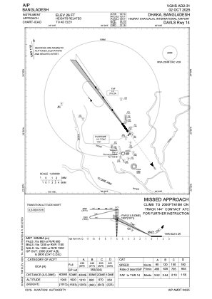
IAC chart of VGHS
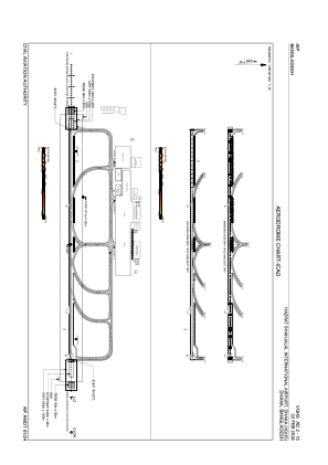
 ADC chart of VGHS
 Satellite view of VGHS
ADC chart of VGHS
Satellite view of VGHS
Sorry, we have no imagery here.
Sorry, we have no imagery here.
Sorry, we have no imagery here.
Sorry, we have no imagery here.
Sorry, we have no imagery here.
Sorry, we have no imagery here.


VGHS - Hazrat Shahjalal International Airort, Dhaka
Located in Dhaka, Bangladesh
ICAO - , IATA - DAC
Data provided by AirmateGeneral information
Coordinates: N23°50'36" E90°23'52"
Elevation is 27 feet MSL.
View others Airports in Dhaka Division
Operational data
Special qualification required
Current time UTC:
Current local time:
Weather
METAR: VGHS 210200Z 15005KT 3500 HZ SCT012 BKN100 27/23 Q1007 NOSIG
TAF: TAF VGHS 202300Z 2100/2206 16008KT 4000 HZ SCT012 BKN100 TEMPO 2100/2109 28025G35KT 2000 RA/TSRA BKN007 FEW025CB OVC090 BECMG 2110/2112 3500 HZ TEMPO 2118/2206 28025G35KT 2000 TSRA/RA BKN007 FEW025CB OVC090
Communications frequencies: [VIEW]
Runways:
| RWY identifier | QFU | Length (ft) | Width (ft) | Surface | LDA (ft) |
| 14 | 144° | 10499 | 148 | UNK | |
| 32 | 324° | 10499 | 148 | UNK |
Airport contact information
Address: Dhaka Bangladesh
Satellite view of VGHS
Sorry, we have no imagery here.
Sorry, we have no imagery here.
Sorry, we have no imagery here.
Sorry, we have no imagery here.
Sorry, we have no imagery here.
Sorry, we have no imagery here.