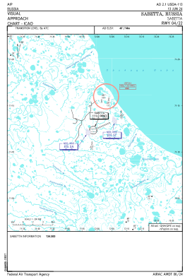
VAC chart of USDA
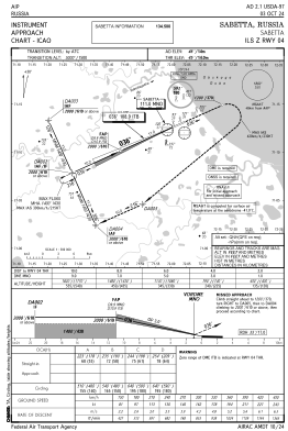
 IAC chart of USDA
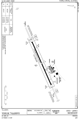
 ADC chart of USDA
 Satellite view of USDA
IAC chart of USDAADC chart of USDA
Satellite view of USDA
Sorry, we have no imagery here.
Sorry, we have no imagery here.
Sorry, we have no imagery here.
Sorry, we have no imagery here.
Sorry, we have no imagery here.
Sorry, we have no imagery here.


USDA - Sabetta
Located in Seyakha, Russian Federation
ICAO - , IATA - SBT
Data provided by AirmateGeneral information
Coordinates: N71°12'52" E72°2'20"
Elevation is 46 feet MSL.
Magnetic variation is 30° East View others Airports in Yamalo-Nenets Autonomous Okrug
Operational data
Special qualification required
Current time UTC:
Current local time:
Weather at : - ( 0 km )
METAR: KUNV 221553Z 21009KT 5SM -RA BR SCT014 BKN018 12/11 A2974
Communications frequencies: [VIEW]
Runways:
| RWY identifier | QFU | Length (ft) | Width (ft) | Surface | LDA (ft) |
| 04 | 66° | 8868 | 151 | UNK | |
| 22 | 246° | 8868 | 151 | UNK |
Airport contact information
Address: Seyakha Russian Federation
Satellite view of USDA
Sorry, we have no imagery here.
Sorry, we have no imagery here.
Sorry, we have no imagery here.
Sorry, we have no imagery here.
Sorry, we have no imagery here.
Sorry, we have no imagery here.