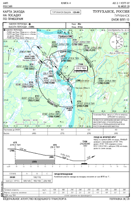
IAC chart of UOTT
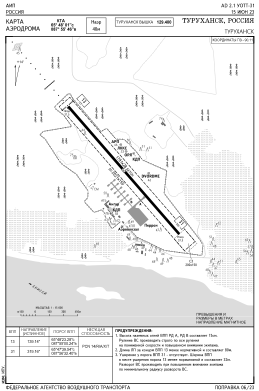
 ADC chart of UOTT
 Satellite view of UOTT
ADC chart of UOTT
Satellite view of UOTT
Sorry, we have no imagery here.
Sorry, we have no imagery here.
Sorry, we have no imagery here.
Sorry, we have no imagery here.
Sorry, we have no imagery here.
Sorry, we have no imagery here.


UOTT - Turukhansk Airport
Located in Turukhansk, Russian Federation
ICAO - UOTT, IATA - THX
Data provided by AirmateGeneral information
Coordinates: N65°48'0" E87°55'48"
Elevation is 128 feet MSL.
View others Airports in Krasnoyarsk Krai
Operational data
Special qualification required
Current time UTC:
Current local time:
Weather at : - ( 0 km )
METAR: YMAV 281158Z AUTO 27010KT 9999 // BKN014 BKN018 OVC029 12/09 Q1023
Communications frequencies: [VIEW]
Runways:
| RWY identifier | QFU | Length (ft) | Width (ft) | Surface | LDA (ft) |
| 13 | 0° | 5876 | 92 | UNK | |
| 31 | 0° | 5876 | 92 | UNK |
Airport contact information
Address: Turukhansk Russian Federation
Satellite view of UOTT
Sorry, we have no imagery here.
Sorry, we have no imagery here.
Sorry, we have no imagery here.
Sorry, we have no imagery here.
Sorry, we have no imagery here.
Sorry, we have no imagery here.