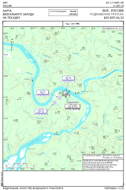
VAC chart of UNIP
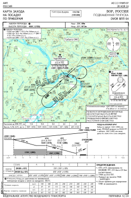
 IAC chart of UNIP
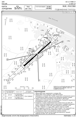
 ADC chart of UNIP
 Satellite view of UNIP
IAC chart of UNIPADC chart of UNIP
Satellite view of UNIP
Sorry, we have no imagery here.
Sorry, we have no imagery here.
Sorry, we have no imagery here.
Sorry, we have no imagery here.
Sorry, we have no imagery here.
Sorry, we have no imagery here.


UNIP - Podkamennaya Tunguska Airport
Located in Bor, Russian Federation
ICAO - UNIP, IATA -
Data provided by AirmateGeneral information
Coordinates: N61°35'30" E89°59'59"
Elevation is 213 feet MSL.
View others Airports in Krasnoyarsk Krai
Operational data
Special qualification required
Current time UTC:
Current local time:
Weather at : - ( 0 km )
METAR: KQFX 220210Z AUTO 01004KT 9999 OVC026 21/16 A2974 RMK A02 TSNO
Communications frequencies: [VIEW]
Runways:
| RWY identifier | QFU | Length (ft) | Width (ft) | Surface | LDA (ft) |
| 04 | 0° | 5584 | 92 | UNK | |
| 22 | 0° | 5584 | 92 | UNK |
Airport contact information
Address: Bor Russian Federation
Satellite view of UNIP
Sorry, we have no imagery here.
Sorry, we have no imagery here.
Sorry, we have no imagery here.
Sorry, we have no imagery here.
Sorry, we have no imagery here.
Sorry, we have no imagery here.