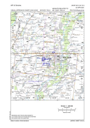
VAC chart of UKHP
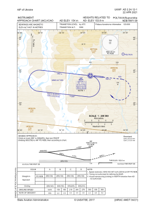
 IAC chart of UKHP
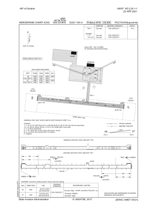
 ADC chart of UKHP
 Satellite view of UKHP

IAC chart of UKHPADC chart of UKHP
Satellite view of UKHP
Sorry, we have no imagery here.
Sorry, we have no imagery here.
Sorry, we have no imagery here.
Sorry, we have no imagery here.
Sorry, we have no imagery here.
Sorry, we have no imagery here.


UKHP - Poltava/Suprunivka
Located in Poltava, Ukraine
ICAO - UKHP, IATA - PLV
Data provided by AirmateGeneral information
Coordinates: N49°34'10" E34°23'39"
Elevation is 505 feet MSL.
Magnetic variation is +7° East View others Airports in Poltava
Operational data
Special qualification required
Current time UTC:
Current local time:
Weather at : - ( 0 km )
METAR: UUBC 190511Z 27002MPS 2500 1400NW SHSN BKN007 BKN033CB M06/M07 Q1019 R31/490140 NOSIG RMK QFE747/0996
Communications frequencies: [VIEW]
Runways:
| RWY identifier | QFU | Length (ft) | Width (ft) | Surface | LDA (ft) |
| 09 | 96° | 8366 | 138 | CONC | 8366 |
| 27 | 276° | 8366 | 138 | CONC | 8366 |
Airport contact information
Address: Poltava Ukraine
Satellite view of UKHP
Sorry, we have no imagery here.
Sorry, we have no imagery here.
Sorry, we have no imagery here.
Sorry, we have no imagery here.
Sorry, we have no imagery here.
Sorry, we have no imagery here.