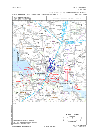
VAC chart of UKHK
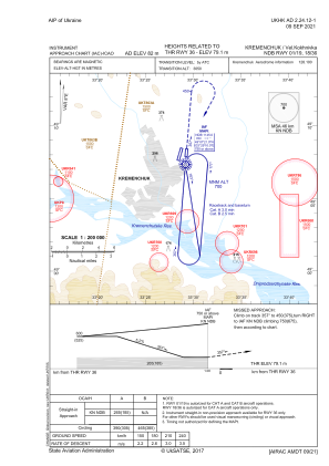
 IAC chart of UKHK
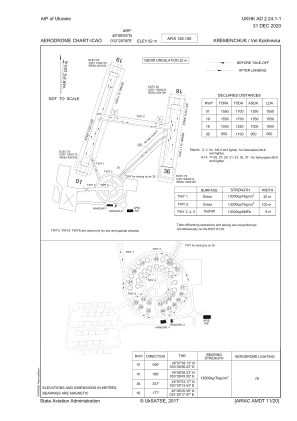
 ADC chart of UKHK
 Satellite view of UKHK

IAC chart of UKHKADC chart of UKHK
Satellite view of UKHK
Sorry, we have no imagery here.
Sorry, we have no imagery here.
Sorry, we have no imagery here.
Sorry, we have no imagery here.
Sorry, we have no imagery here.
Sorry, we have no imagery here.


UKHK - Kremenchuk/Velyka Kokhnivka
Located in Kremenchuk, Ukraine
ICAO - , IATA - KHU
Data provided by AirmateGeneral information
Coordinates: N49°8'3" E33°28'36"
Elevation is 269 feet MSL.
Magnetic variation is 8° East View others Airports in Poltava
Operational data
Special qualification required
Current time UTC:
Current local time:
Weather at : - ( 0 km )
METAR: CWND 191333Z M01/M01 RMK 6015 T10121007
Communications frequencies: [VIEW]
Runways:
| RWY identifier | QFU | Length (ft) | Width (ft) | Surface | LDA (ft) |
| 01 | 14° | 5249 | 246 | GRASS | 5085 |
| 19 | 194° | 5249 | 246 | GRASS | 5085 |
| 18 | 185° | 3281 | 361 | GRASS | 3281 |
| 36 | 5° | 3281 | 361 | GRASS | 3117 |
Airport contact information
Address: Kremenchuk Ukraine
Satellite view of UKHK
Sorry, we have no imagery here.
Sorry, we have no imagery here.
Sorry, we have no imagery here.
Sorry, we have no imagery here.
Sorry, we have no imagery here.
Sorry, we have no imagery here.